JPL's Wireless Communication Reference WebsiteChapter: Network Concepts and Standards |
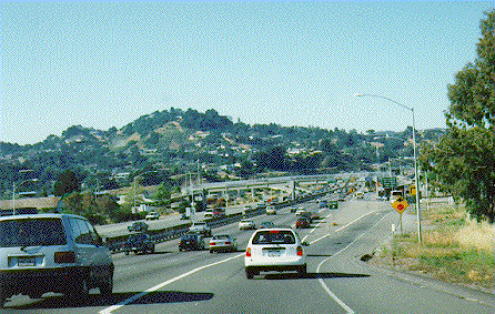 The growth of road traffic and the increasing inconvenience and environmental damage
caused by road congestion require a substantially more efficient
use of the infrastructure for physical transport.
In contrast to many measures taken in the past,
advanced solutions will require a wireless
communications infrastructure
for vehicles communicating with roadside base stations
and vice versa and with other (nearby) vehicles. This will require extensive use of
mobile radio communication, in addition to the present desire to extend conventional
services, such as cellular and personal telephony and wireless electronic mail, to mobile subscribers.
The growth of road traffic and the increasing inconvenience and environmental damage
caused by road congestion require a substantially more efficient
use of the infrastructure for physical transport.
In contrast to many measures taken in the past,
advanced solutions will require a wireless
communications infrastructure
for vehicles communicating with roadside base stations
and vice versa and with other (nearby) vehicles. This will require extensive use of
mobile radio communication, in addition to the present desire to extend conventional
services, such as cellular and personal telephony and wireless electronic mail, to mobile subscribers.
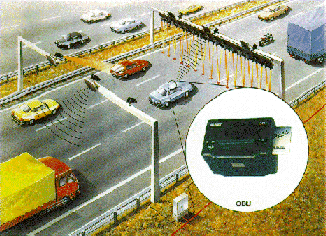 Figure: Electronic Toll Collection using Digital Short-Range Communication.
Transactions are made in a few tens of milliseconds.
Figure: Electronic Toll Collection using Digital Short-Range Communication.
Transactions are made in a few tens of milliseconds.
Courtesy: Bosch Telekom, Germany.
DRIVE distinguishes seven inter-related areas of major interest:
ITS distinguishes six inter-related system areas:
With respect to operational implementations of transportation telematics, Japan is indisputably far ahead of both Europe and the USA: about 1/3 of the circa 135,000 signalized intersections in Japan are under central computer control, almost all large metropolitan areas are provided with video camera's and ultrasonic technology connected to traffic information boards and variable message signs, in over 75 metropolitan areas traffic management centers are operational, and about 400,000 in-car navigation systems have been sold.
To achieve a system optimum, ATMS require relevant information about the actual system performance on the entire road infrastructure under consideration. Only in this way, ATMS can dynamically adjust or distribute the actually offered traffic to or over the available infrastructural capacity by means of traffic management measures. The information about the actual status of the traffic (and the infrastructure) should be available in real-time (e.g. in time intervals of 1 to 5 minutes) and concerns traffic data that is aggregated to a certain extent. An important characteristic of ATMS applications is that decisions are made and measures are (seen to be) implemented by traffic managers in the traffic center, which complete the collected external data collections with know-how gathered by training and experience.
Since the administrators of ATMS applications are the road authorities, which are also responsible for the road infrastructure, an ATMS monitoring system is obviously based on fixed traffic detectors that are mounted in, above or along the road infrastructure. We will refer to this type of detectors as infrastructure based traffic detectors. As a consequence of the network-wide oriented nature of ATMS, an ATMS monitoring system using fixed, infrastructure based traffic detectors (e.g. inductive loops) is characterized by rather large detector spacings (typically of 5 to 10 kilometers. Shorter distances between the detectors would make such a network-wide monitoring system financially prohibitive.
A typical example of an ATMS application is Incident Management, which deals with swiftly detecting disturbances in the traffic flows, estimating expected delay, determining spare capacity of the remaining road links and proportionally distributing traffic over the entire network.
The instruments belonging to the class of ATCS are more or less rigid standard operations, which can be fully automated and need no human intervention. Hence, according to the definition of information systems given before, ATCS constitute no true information system (the component 'persons' is not involved). The exact objectives of the particular ATCS can be modified by the corresponding ATMS, for instance by adjusting certain parameters. The complexity of computer models and the calculation speed of computers restrict area-wide application of ATCS, because computations and actions need to be performed in real-time. The data collections for ATCS should be very accurate, possibly relate to individual vehicles and be directly available in real-time (e.g. in intervals of several seconds to 1 minute).
As a consequence of the local oriented nature of ATCS, an ATCS monitoring system exclusively concerns the direct vicinity of the corresponding (ATCS) traffic control system and basically only provides traffic data for this control system. Moreover, only fixed, infrastructure based traffic detectors (e.g. inductive loops) with very small detector spacings (typically of some hundreds of meters) will be suitable. Since ATCS applications concern only a very limited geographical area, these detector spacings are financially affordable. Longer distances between the detectors, or utilization of non-infrastructure based traffic detectors is not eligible as this can only provide data with a accuracy and a reliability that will be too low for ATCS.
A typical example of an ATC system application is ramp metering, which deals with gradually allowing vehicles on the on-ramp to enter the freeway, depending on the proportion between the actual flow and capacity of the freeway. Almost all traffic systems that are currently employed belong to the class of ATCS applications.
For the purpose of supporting and achieving several individual users' optima, ATIS require information about complete routes from origin to destination, about delays on the regular route, about the travel time on alternative routes and about alternative ways of available transport, at the moment of passage. This implies that specific parts of different networks (urban, rural and state) that are relevant during a specific trip are of interest, with information about delays on routes at the moment they will actually be used (requiring short term predictions) instead of instantaneous information. Hence, the regular traffic information to be obtained for ATIS purposes may become available every rather long time interval of for instance 5 to 15 minutes (incidents should be reported more swiftly). These characteristics are in sharp contradiction to the information requirements of ATMS applications, which demand predominantly actual (i.e. real-time) information about one, but entire network.
As a consequence of the established characteristics of ATIS information, i.e. both area-wide and concerning several networks that cover each entire route, an ATIS monitoring system can not always practically be based on fixed, infrastructure based traffic detectors. In particular installing fixed traffic detectors in an entire urban road network, requiring extremely short detector spacings due to the close-meshed urban road infrastructure, would be unrealistic. Furthermore, in consideration of the opposite objectives of ATMS and ATIS, an ATIS monitoring system should preferably be independent of an ATMS monitoring system and preferably be based on anything but infrastructure based traffic detectors exploited by government or state. For these specific ATIS purposes, one can use a monitoring system based on non-infrastructure based detectors, such as probe vehicles. These are normal vehicles that participate in the traffic flow, are equipped with a location and communication device and accordingly transmit experienced traffic data to a traffic center.
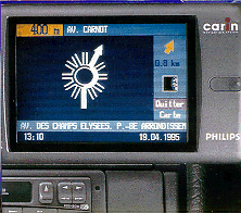 Photo: Screen of Philips CARIN navigation system. A typical example of an ATIS application is Dynamic Route Guidance, which deals with guiding the individual car driver whose vehicle is equipped with such a DRG-device, from its origin to its specified destination, along the best route (e.g. shortest in time), according to real-time traffic situations. |
 Transportation and electronic industries and (conjoint) car
manufacturers develop, operate and administrate the ATIS applications, whereas their (indirect)
goal is a commercial one, that is to make profit with a product for which the consumer is
willing to pay. Besides, also transportation authorities pay attention to transportation telematics
applications which are destined for providing road users with actual traffic information (such as
variable message signs, VMS). We gather these latter telematics applications among the class of
ATMS, as their principal aim remains optimizing the existing transportation infrastructure,
either directly by means of deploying measures or indirectly by means of disseminating
information. This means that also the information provided by ATMS is first of all aimed at this
objective and is not necessarily optimal for each individual road user.
Transportation and electronic industries and (conjoint) car
manufacturers develop, operate and administrate the ATIS applications, whereas their (indirect)
goal is a commercial one, that is to make profit with a product for which the consumer is
willing to pay. Besides, also transportation authorities pay attention to transportation telematics
applications which are destined for providing road users with actual traffic information (such as
variable message signs, VMS). We gather these latter telematics applications among the class of
ATMS, as their principal aim remains optimizing the existing transportation infrastructure,
either directly by means of deploying measures or indirectly by means of disseminating
information. This means that also the information provided by ATMS is first of all aimed at this
objective and is not necessarily optimal for each individual road user.
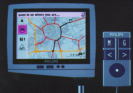
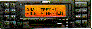 Photo: Philips car radio system, displaying traffic information
about the A12 motorway in Holland.
Photo: Philips car radio system, displaying traffic information
about the A12 motorway in Holland.
ATIS systems may make use of systems for Traffic Information Datacasting, such as RDS.


