JPL's Wireless Communication Reference WebsiteChapter: Network Concepts and Standards
|
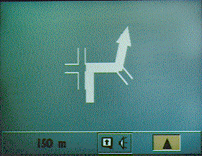
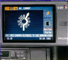 Under the EUREKA program, the CARin MINerve ATlas (CARMINAT) project (combining
Philips' CARIN navigation system with the traffic information concept MINERVE and
Renault's ATLAS project) is investigating the use of RDS-TMC to enable CARIN to react to
changes in traffic conditions.
The French version of CARMINAT is called INF-LUX.
Trafficmaster is a hand-held or dashboard-mounted traffic information system for drivers on
the
M25 and interconnecting motorways around London, that issues congestion warnings
detected by infra-red sensors mounted on motorway bridges and conveys this information in map
display form.
Under the EUREKA program, the CARin MINerve ATlas (CARMINAT) project (combining
Philips' CARIN navigation system with the traffic information concept MINERVE and
Renault's ATLAS project) is investigating the use of RDS-TMC to enable CARIN to react to
changes in traffic conditions.
The French version of CARMINAT is called INF-LUX.
Trafficmaster is a hand-held or dashboard-mounted traffic information system for drivers on
the
M25 and interconnecting motorways around London, that issues congestion warnings
detected by infra-red sensors mounted on motorway bridges and conveys this information in map
display form.
PATHFINDER is an extension of the ETAK navigator with dynamic traffic information, with the addition of a speech synthesizer and a two-way radio for transceiving data. Without congestion information the PATHFINDER system continues to function as a standard ETAK navigator.
TravTek is an experiment in Orlando, Florida, to enable assessment and evaluation of the potential benefits and effects of implementation of providing car drivers with navigation and dynamic information, which involves the deployment of 100 vehicles equipped with in-vehicle display units.
In Japan, the development of in-car information and communication systems started in 1973, with the initiation of a national research and development program known as Comprehensive Automobile Traffic Control System (CACS), focusing on: route guidance (based on two-way digital communications via inductive loop transmissions), driving information, route display board and traffic incident information. As from 1979, when CACS was ceased, this led to the following two independent and competing programs. The Road/Automobile Communication System (RACS) was initiated in 1984 by the governmental Highway Industry Development Organisation (HIDO) to investigate the requirements of a system to provide two- way, real-time data exchange between vehicles and road-side units. This system was intended to use three micr wave type beacons: location beacons, traffic information beacons and individual communication beacons.
Also in 1984, the Advanced Mobile Traffic Information and Communication System (AMTICS) was conducted by the Ministry of Posts and Telecommunications (MPT). The concept AMTICS was, like RACS, to provide information from a central control center, to a navigation unit and display terminal on board the vehicles, by using cellular type terminals.
 It is also planned that SOCRATES will
supply
CARIN and TravelPilot systems with dynamic traffic information. ADVANCE, is a project by
the Illinois Universities Transportation Research Consortium, which constitutes one of the
most
ambitious demonstration and research initiatives into the effects and benefits of DRG
systems
and includes approximately 4,000 equipped vehicles in Chicago. In 1990, it was announced
by
the Ministry of Posts and Telecommunications (MPT) that RACS and AMTICS were to be
combined in the Vehicle Information and Communication System (VICS) in order to work
towards a joint development of vehicle information systems in Japan.
It is also planned that SOCRATES will
supply
CARIN and TravelPilot systems with dynamic traffic information. ADVANCE, is a project by
the Illinois Universities Transportation Research Consortium, which constitutes one of the
most
ambitious demonstration and research initiatives into the effects and benefits of DRG
systems
and includes approximately 4,000 equipped vehicles in Chicago. In 1990, it was announced
by
the Ministry of Posts and Telecommunications (MPT) that RACS and AMTICS were to be
combined in the Vehicle Information and Communication System (VICS) in order to work
towards a joint development of vehicle information systems in Japan.
Furthermore, in Britain CARFAX is being used, while in German speaking countries from around 1974 we find the Autofahrer Rundfunk Information (ARI), that alerts drivers for an upcoming traffic information broadcast, and ARI aufgrund Aktueller Messdaten (ARIAM), which uses automatic incident detection devices to reduce the elapsed time between observing and reporting traffic disturbances.
In the USA, Highway Advisory Radio (HAR) is operational, which is a special short-ranged radio that spatially localizes traffic information messages, using dedicated amplitude modulation (AM) transmitters located at the roadside, and Advanced Highway Advisory Radio (AHAR), which is a more advanced version of HAR, which provides an automatic interrupt when an advisory message is available.


![]()